No matter the time of year, communities throughout the U.S. face risk of weather events that could affect the electric grid. Public power utilities planning for these risks should stay aware of when these risks are most likely to occur — and how their frequency, intensity, and geographic reach are changing.
Flooding

 | Flooding can occur at any time of year and is a risk across the United States, from heavy rain, snowmelt, or coastal storm surges. Flooding causes an average of $5 billion a year in damage in the U.S — more than any other severe weather-related event. Critical infrastructure facilities at risk of flooding are anticipated to increase 6% through 2050. |
Hurricanes and Tropical Storms

 | More category 3 or greater hurricanes developed in the Atlantic in the last 25 years (91) than did in 40 years from 1960-1999 (81). |
Tornadoes

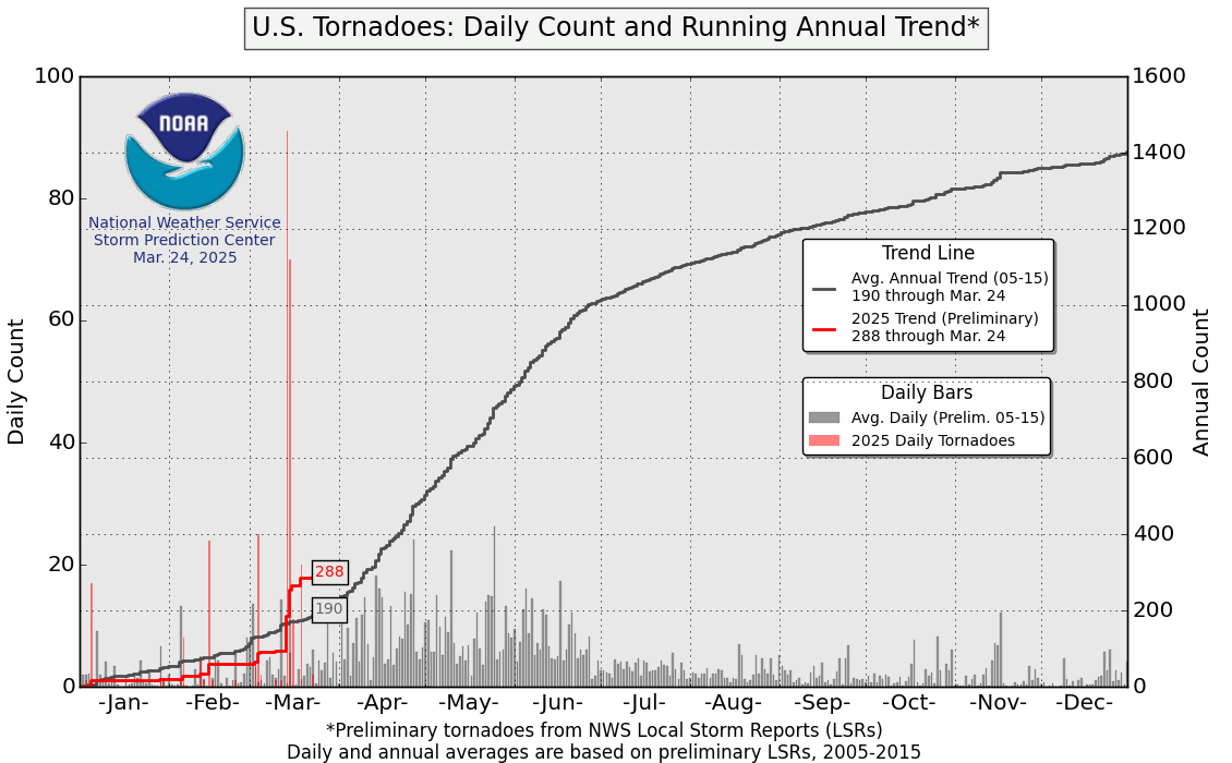
 | Risk of destructive tornadoes, historically concentrated in Kansas, Nebraska, Oklahoma, and Texas, is shifting east into Alabama, Arkansas, Kentucky, Louisiana, Mississippi, and Tennessee. The high risk in Florida is also extending to more of the southeast, which is seeing more days with conditions conducive to tornado development. |
Wildfires

 | While risk of wildfire is year-round and dependent on region, the peak wildfire season in the U.S. has extended by two months since the 1950s. Wildfire risk is still highest in the arid parts of the western United States, but they are becoming more common in the Great Plains, Midwest, and Alaska. |
Winter Storms

 | While blizzards are expected to continue to become less frequent, risk of freezing rain, leading to ice accumulation, is increasing in northern parts of the U.S. |
Utilities can explore risks specific to their area with tools such as the Federal Emergency Management Agency’s Resilience Analysis and Planning Tool.
Sources
- NOAA National Hurricane Center, Tropical Cyclone Climatology
- NOAA National Hurricane Center, Atlantic Storm Totals Table
- Western Fire Chiefs Association, When is Wildfire Season?
- The Weather Channel, Here are the Winter Storm Names for 2025-2026
- “Frequency of U.S. Blizzards May Decline in Coming Decades,” University of Nebraska-Lincoln, February 13, 2024.
- DelPizzo, J., Baule, W. J., Tobias-Tarsh, L., Notaro, M., & Rood, R. B. (2025). Climatology and Recent Changes in the Occurrence of Freezing Rain throughout the Laurentian Great Lakes Region. Journal of Applied Meteorology and Climatology, 64(10), 1395-1409. https://doi.org/10.1175/JAMC-D-24-0204.1
- NOAA National Severe Storms Laboratory, Severe Weather 101 – Floods
- NOAA Weather Prediction Center, Excessive Rainfall Outlook
- First Street Foundation, The 3rd National Risk Assessment
- National Centers for Environmental Information, U.S. Tornadoes
- National Weather Service Storm Prediction Center, U.S. Tornadoes: Daily Count and Running Annual Trend